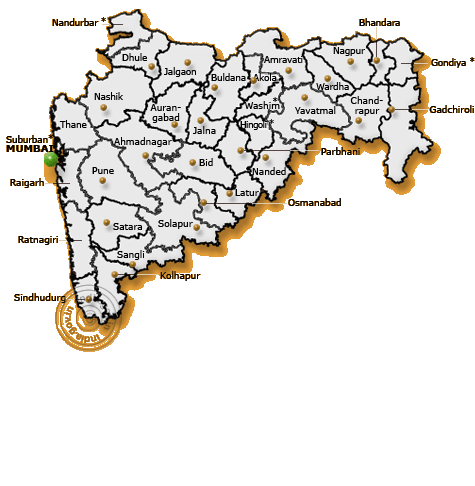
Districts of Maharashtra
DISTRICTS OF MAHARASHTRA
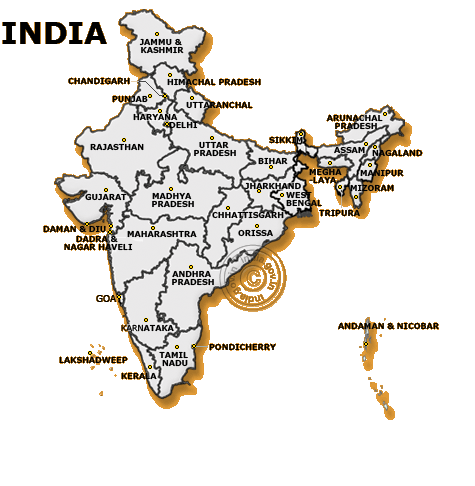
Maharashtra state is made up of 35 districts, which are grouped into six divisions. Population data are from the 2001 Census of India
India
Amravati Division 9,941,903
Akola District 1,629,305
Amravati District 2,606,063
Buldhana District or ( Buldana ) 2,226,328
Washim District 1,019,725
Yavatmal District 2,460,482
Aurangabad Division (Marathwada) 15,589,223
Aurangabad District 2,920,548
Beed District 2,159,841
Hingoli District 986,717
Jalna District 1,612,357
Latur District 2,078,237
Nanded District 2,868,158
Osmanabad District 1,472,256
Parbhani District 1,491,109
Konkan Division 24,807,357
Mumbai City District 3,326,837
Mumbai Suburban District 8,587,561
Raigad District 2,205,972
Ratnagiri District 1,696,482
Sindhudurg District 861,672
Thane District 8,128,833
Nashik Division 15,774,064
Ahmednagar District 4,088,077
Dhule District 1,708,993
Jalgaon District 3,679,936
Nandurbar District 1,309,135
Nashik District 4,987,923
Nagpur Division 10,665,939
Bhandara District 1,135,835
Chandrapur District 2,077,909
Gadchiroli District 969,960
Gondiya District 1,200,151
Nagpur District 4,051,444
Wardha District 1,230,640
Pune Division 19,973,761
Kolhapur District 3,515,413
Pune District 7,224,224
Sangli District 2,581,835
Satara District 2,796,906
Solapur District 3,855,383
Konkan or Kokan is also one of six divisions of the state of Maharashtra
The Sanskrit term Konkanashta, meaning "Native of Konkan", is used to refer to the Chitpawan, a Brahmin caste of the region.
Latitude: 15° 36' and 18°05'N
Longitude: 73° 05' and 74° 36'E
Climate: Tropical
Clothing: Cotton Clothes
Food: Rice, fish and wheat are the staple diet of the people.
Language:The principal language is Marathi
STD code: 02352
Maharashtra state is made up of 35 districts, which are grouped into six divisions. Population data are from the 2001 Census of
 India
India Amravati Division 9,941,903
Akola District 1,629,305
Amravati District 2,606,063
Buldhana District or ( Buldana ) 2,226,328
Washim District 1,019,725
Yavatmal District 2,460,482
Aurangabad Division (Marathwada) 15,589,223
Aurangabad District 2,920,548
Beed District 2,159,841
Hingoli District 986,717
Jalna District 1,612,357
Latur District 2,078,237
Nanded District 2,868,158
Osmanabad District 1,472,256
Parbhani District 1,491,109
Konkan Division 24,807,357
Mumbai City District 3,326,837
Mumbai Suburban District 8,587,561
Raigad District 2,205,972
Ratnagiri District 1,696,482
Sindhudurg District 861,672
Thane District 8,128,833
Nashik Division 15,774,064
Ahmednagar District 4,088,077
Dhule District 1,708,993
Jalgaon District 3,679,936
Nandurbar District 1,309,135
Nashik District 4,987,923
Nagpur Division 10,665,939
Bhandara District 1,135,835
Chandrapur District 2,077,909
Gadchiroli District 969,960
Gondiya District 1,200,151
Nagpur District 4,051,444
Wardha District 1,230,640
Pune Division 19,973,761
Kolhapur District 3,515,413
Pune District 7,224,224
Sangli District 2,581,835
Satara District 2,796,906
Solapur District 3,855,383
Konkan or Kokan is also one of six divisions of the state of Maharashtra
Residents of Konkan and their descendants are called Konkanis. The name may also refer specifically to the Konkani people, an ethnic group of the region; most of them speak the Konkani language, which is from the Indo-European family of languages.
The Sanskrit term Konkanashta, meaning "Native of Konkan", is used to refer to the Chitpawan, a Brahmin caste of the region.
Boundaries
The precise definition of Konkan varies, but mostly it includes Maharashtra's districts of Thane, Raigad, Ratnagiri and Sindhudurg, the state of Goa and Mumbai.
The Konkan division
The Konkan division of Maharashtra comprises the entire coastal region of the state, including Mumbai.
Area: 30,746 km²
Population (2001 census): 24,807,357
Districts: Mumbai, Mumbai Suburban, Raigarh, Ratnagiri, Sindhudurg, Thane
Literacy: 81.36%
Area under irrigation: 4,384.54 km²
Area: 30,746 km²
Population (2001 census): 24,807,357
Districts: Mumbai, Mumbai Suburban, Raigarh, Ratnagiri, Sindhudurg, Thane
Literacy: 81.36%
Area under irrigation: 4,384.54 km²
Mumbai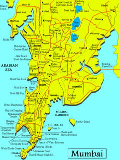

Mumbai City District is a district of Maharashtra. A city district, it has no headquarters or subdivisions. It, along with the Mumbai Suburban District make up the metropolis of Mumbai. The city area is called the "island city" or South Bombay or Old Bombay. It extends from Colaba in the south to Mahim and Sion in the north. Until the 1960s, (1964?) the area was known as Mumbai. Today, Mumbai municipality includes both districts.
This is the most advanced district in Maharashtra. It had a population of 3,338,031 of which 100% were urban as of 2001
This is the most advanced district in Maharashtra. It had a population of 3,338,031 of which 100% were urban as of 2001
Mumbai suburban district 
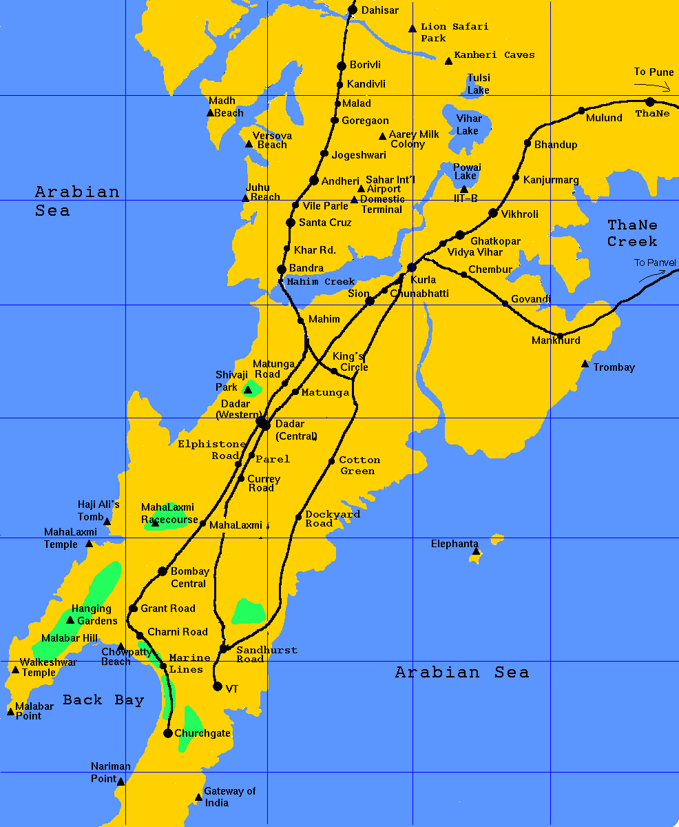
The Mumbai suburban district is a district of the state of Maharashtra, India. Its headquarters is Bandra (East). It consists of three administrative subdivisions or tehsils: Kurla, Borivali and Andheri. The district along with Mumbai City district make up the metropolis of Mumbai. Total area: 370 sq km.
This is the second-most advanced district in Maharashtra. It had a population of 8,640,419 of which 100% were urban as of 2001.
This is the second-most advanced district in Maharashtra. It had a population of 8,640,419 of which 100% were urban as of 2001.
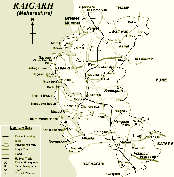
Raigad District
Raigad District is a district in the Indian state of  Maharashtra. It is located in the Konkan region. The district was renamed after Raigad, the fort and former capital of the Maratha leader Shivaji, which is located in the interior forests of the district, on a west-facing spur of the Western Ghats or Sahyadri range. The district had a population of 2,207,929 of which 24.22% were urban as of 2001. [1]
The district is bounded by Mumbai Harbour to the northwest, Thane District to the north, Pune District to the east, Ratnagiri District to the south, and the Arabian Sea to the west. It includes the large natural harbor of Pen-Mandwa, which is immediately south of Mumbai Harbour, and forming a single landform with it. Part of the district is included in the planned metropolis of New Bombay, and its port, the Jawaharlal Nehru Port.
The district includes Kashid and Kihim beaches, besides the towns of Mahad and Panvel.
The district also includes the isle of Gharapuri or Elephanta, located in Mumbai Harbor which has ancient Hindu and Buddhist caves.
 Maharashtra. It is located in the Konkan region. The district was renamed after Raigad, the fort and former capital of the Maratha leader Shivaji, which is located in the interior forests of the district, on a west-facing spur of the Western Ghats or Sahyadri range. The district had a population of 2,207,929 of which 24.22% were urban as of 2001. [1]
The district is bounded by Mumbai Harbour to the northwest, Thane District to the north, Pune District to the east, Ratnagiri District to the south, and the Arabian Sea to the west. It includes the large natural harbor of Pen-Mandwa, which is immediately south of Mumbai Harbour, and forming a single landform with it. Part of the district is included in the planned metropolis of New Bombay, and its port, the Jawaharlal Nehru Port.
The district includes Kashid and Kihim beaches, besides the towns of Mahad and Panvel.
The district also includes the isle of Gharapuri or Elephanta, located in Mumbai Harbor which has ancient Hindu and Buddhist caves.
History
The district was called Colaba or Kulaba during British rule, a name that is derived from it ancient form, and which means the "Land of the Koli". The Koli are an adivasi, or tribal people.
Later the district was renamed to Alibaug, after the Muslim African principality of Murud-Janjira was merged into it after 1947; the town of Alibaug is the largest urban settlement and the capital of the district.
The fort of Murud was being built by minor Koli chieftains as part of their defense against piracy when, by a stratagem, Siddis (African Muslims from Somalia), slaves and employees of the Bahamani Sultanate, seized it and made it their headquarters.
The tiny Muslim state of Murud-Janjira withstood attempts by many local powers, such as the Portuguese, English, Marathas, etc. to seize it but was never conquered. It allied at different times with different powers, often with the Mughal Empire and thrived off piracy. The Siddis even attempted to seize Bombay from England, and actually succeeded in overwhelming the English force but were driven out by a militia organized by a Parsi settler from among the natives who had immigrated from Surat. Finally, it entered the system of subsidiary alliance with Britain, becoming a princely state of British India, in which condition it remained until 1947, when it acceded to newly-independent India.
Thane District
Thane (formerly Thana) is a city in Maharashtra, India, part of the Mumbai Conurbation, northeast of Mumbai at the head of the Thane Creek. It is the administrative headquarters of Thane District.
Thane (pronounced Thaanai by the locals) is a district in northern Maharashtra in India. The capital of the district is the city of Thane. Other major cities in the region are Navi Mumbai (formerly New Bombay), Kalyan-Dombivli, Mira-Bhayander, Bhiwandi, Ulhasnagar,Ambernath, Kulgaon-Badlapur, Dahanu, Shahapur, Wada and Vasai-Virar. This is the third-most advanced district in Maharashtra. It had a population of 8,131,849 of which 72.58% were urban as of 2001. [1] Thane comprises of 13 talukas. The southern talukas are the location of urban areas and hence urban Indians while the western coastal region is mostly populated by Kolis, Marathi and Gujaratis. The northern and the eastern talukas are populated by the Warli tribes, known for making stark images from red mud on house walls.
Brief History
The name "Thane" is said to be derived from Sthan or Sthanaka, the capital of the Shilahara kings of Konkan. It is currently the headquarters of Thane district. The earlist evidence of Thane appears in the works of the Greek geographer, Ptolemy, who, in his writings (135-150) refers to a place called Chersonesus, which, according to researches, is the area around Thane creek. Slabs and copper plates dating back to the middle ages have also been discovered in Thane. Venetian traveller Marco Polo also visited Thane in 1290. He describes the city as a great kingdom, which apparently had a well-developed port, for he mentions a continuous traffic of ships, and merchants trading and exporting leather, buckram, cotton, and importing horses. The Portuguese came to Thane about 1530 and ruled for over 200 years till 1739. Thane was then known as Cacabe de Tana. Work on the Thane Fort began in 1730. The Marathas, who conquered Bassein and Thane in 1737 and 1739, held sway over the region till 1784, when the British captured the Fort and ruled Thane, then also called Tana. They made it the headquarters of the district administration with a district collector stationed in Thane. The Thane Municipal Council was formed in 1863 when the city had a population of 9000. The first railway train in India ran from Bombay VT (Now Mumbai CST, See Mumbai) to Thana in 1853. Thane (or Thana) literally means "station" in Marathi the local language. It was the only railway station besides Victoria Terminus. After India's independence, Thane grew slowly and became an industrial town in the '60s and '70s. There was also a corresponding growth in trade, transport and construction activities, which picked up tremendously in the '80s. Once considered as the 'ugly twin' of Mumbai, today Thane outshines Mumbai cvbcvin its planning and neatness. Even as it develops at a fast pace, Thane, is also known as the City of Lakes, is still plagued with overcrowding and commuting problems.
History
The city of Thane is situated on the western banks of Thane creek with Parsik hills on the east and Yeour hills on the west. The creek not only provides a natural protection to the place but has also facilitated transport of big and small ships since ancient times. This has also acted as an impetus for the development of local and international trade since the pre-historic times. Besides being the stamping ground of the pre-historic tribes, Thane city has a rich cultural heritage, mythological background, and has been home to many events of historical importance. The history of Thane city can be broadly categorized into 5 eras. Vedic period to 1300. : Comprising of Hindu or ancient period, Aparant, Silhara and Bimba dynasties. 1300 –1660: Muslim and Portuguese rule. 1660-1800: Maratha and Portuguese rule. 1800-1947: British Rule. 1947-till date : Independent India. ‘Aparant’ is the ancient name of the geographical area hosting Thane city. During the Indian expedition of the Greek Emperor Alexander, a number of philosophers, historians and geographists visited India. Among them a Greek historian ‘Tolemi’ has mentioned about the city of Thane in his writings. In the 9th century the city, know as Shreesthanak, was the capital of the Silhara dynasty. The Silharas ruled thane from 810 to 1260. A place called ‘Ghodbunder’ was famous for horse trading thus deriving its name from the word ghoda i.e. horse and bunder meaning port. During this period a fabric called ‘Tansi’ was exported from Thane. The Silhara emperors were disciples of Lord Shiva, and the Kopineshwar Temple was built during their reign. During this period, due to the secular attitude and tolerance of Silharas towards different religions, people from diverse communities including Parsis, Christians, Muslims and Jews settled down in Thane, creating a cosmopolitan city. At this time the Silharas also divided the city into different sections and named them as ‘padas’. These padas exist today, in the names of Naupada, Patlipada, Agripada etc. In the earlier part of the 12th century with a view to create a new township, King Bimbadev, alongwith 66 segments of his community came over and settled in Thane. The explorer Marco Polo visited Thane in 1290 and noted it to be one of the best cities in the world. In 1480 Sultan Mahmud Begara of Gujarat made Thane the capital of his ‘Subha’ Province. The Portuguese ruled Thane for over 200 years from 1530 to 1739. During this period Thane was known as “Kalabe De Tana”. St. John the Baptist Church was constructed in Thane in 1663. Construction of the Thane Killa (Fort) was started in 1730. In 1737 the Maratha general Chimaji Appa the planned the conquest of Vasai (Portuguese Baçaim), and on March 28 1738 the Marathas conquered the Thane Killa. The fort is presently being used as Thane Central Jail. In 1744 the British conquered Thane city and its fort. The famous Kopineshwar Temple was renovated in 1760. In 1778 the palatial residence of the Peshwas was converted into the Court building. In the year 1780 Keshavji Sorabji Rustomji Patel constructed the first Parsi Agyari in Thane. The first District Court was established in 1803. The first railway train ran on April 16 1853 from Boribunder to Thane. The Thane Borough Municipality was established on March 10 1863. The first newspaper in Thane was launched in the year 1866. Different Marathi magazines like Arunodaya, Survodaya, Vakilancha Sathi, Nyaylahari, Manohar, Dyanapradip, Dyanadipika were seen to be in circulation thus showing the importance of the print media during that period. In the year 1880 the Thane Borough Municipality spent Rs. 12,960 on construction of the Pokharan Lake, to supply the town with drinking water. This prestigious project was inaugurated by the then Governor of Bombay Presidency, Sir Ferguson James. The first elections of the Municipality were conducted in 1885. The first census took place in the year 1881 and the population of Thane at the time was 14,456. The Jain temple of Thane was built in 1879. The first ever English medium school was started in 1821 and was named as ‘Thane English School’. In the year 1893, the first Marathi Library was established. In 1896 the birth anniversary of Shivaji Maharaj was celebrated for the first time in Thane. In June 1897 Lokmanya Tilak visited Thane. On April 19 1910 freedom fighters Veer Anant Laxman Kanhere, Gopal Krishnaji Karve, and Vinayak Narayan Deshpande were hanged to death in the Central Jail for killing the Nasik District Collector Jackson. In 1938 freedom fighter Veer Savarkar was fêted by the citizens of Thane after his release from the British confinement. In 1920 a road near Masunda lake was named after Dr. F.A. Moose for the commemorative service during the epidemic of plague. A reputed citizen of Thane Shri Vithal Sayanna’s son Divan Bahadur Narayan Sayanna reconstructed the Civil Hospital building in 1935. India's Independence day, August 15 1947, was celebrated in Thane by bringing down the British Union Jack and hoisting the tri-coloured flag of India at the hands of a freedom fighter Shri Nanasaheb Joshi at the District Collector’s Office. With a view to preserve the rich cultural heritage of Thane, the Thane Municipal Council constructed Rangayatan, a drama theatre, named after the Marathi writer Shri Ram Ganesh Gadkari. The theatre has been hosting different plays and cultural programmes since. The Thane Municipal Corporation was established on 1 October 1982. It had a population of 790,000 as per the 1991 census. The population has reached to about 1,400,000 in the year 2003. The Thane Municipal Corporation has undertaken many development projects and schemes since 1982. One of major projects is the Integrated Road Development Project. Taking in view the all round infrastructural development which has recently taken place in Thane , the Govt. of India conferred the prestigious ‘Clean City Award’ to Thane in the year 2000.
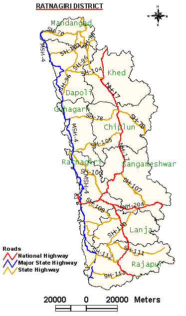
Ratnagiri District
Ratnagiri is a city located in the southwestern part of Maharashtra State on the Arabian Sea coast, in the Ratnagiri district. It forms a part of the greater tract known as Konkan. This tract is historically famous for it long coastline and convenient harbours. 
The surrounding area is bordered by the Sahyadri Hills on the West; the heavy rainfall results into highly eroded landscape in the coastal region. Fertile alluvial valleys produce rice and coconut as the main crops; fruit and cashew nut cultivation is being promoted.
Ratnagiri is noted for the delicious golden Haapus (Alphonso) mangoes that are produced here.
It is here that the great freedom fighter Bal Gangadhar Tilak was born.
Ratnagiri is a district in Maharashtra, India. Ratnagiri nearly 400 km from Mumbai. It has the distinction of being the native place of three Bharat Ratna awardees, namely Maharishi Karve, Dr. Pandurang Vaman Kane and Dr.B.R. Ambedkar. It is the third-most backward district in Maharashtra. The district is 11.33% urban
Adjoining districts: West: Arabian Sea; south: Sindhudurg district; east: Satara, Sangli, Kolhapur districts; north: Raigad district
General information
Latitude: 15° 36' and 18°05'N
Longitude: 73° 05' and 74° 36'E
Climate: Tropical
Clothing: Cotton Clothes
Food: Rice, fish and wheat are the staple diet of the people.
Language:The principal language is Marathi
STD code: 02352
Population: 1,696,777 (2001)
Literacy: 65.13% (2001)
Urbanization: 11.33% (2001)
Literacy: 65.13% (2001)
Urbanization: 11.33% (2001)
History
The district is in the Konkan region of Maharashtra. This region was under the rule of the Mauryas, the Nalas, the Silaharas, the Chalukyas, the Kadambas, the Portuguese, the Marathas and subsequently the British. In 1948 the independent princely state of Sawantwadi was merged with the Indian union and in 1956 with Bombay Province, thus becoming part of Ratnagiri district. In 1960 with the creation of Maharashtra, Ratnagiri became a district of that state. In 1981 Ratnagiri district was bifurcated and the new district of Sindhudurg was created. Ratnagiri has nine tehsils and eight towns.
Sindhudurg District
Sindhudurg (सिंधुदूर्ग in Marathi) is an administrative district in the state of Maharashtra in India, which was carved out of the erstwhile Ratnagiri district. The district headquarters are located at Oros (ओरोस). The district occupies an area of 5207 km² and has a population of 868,825 of which 9.47% were urban (as of 2001). [1] The district is named for the fort of Sindhudurg (which means "fort in the sea"), which lies on a rocky island just off the coast of Malvan (मालवण). It is the second-most backward district in Maharashtra
Location
Sindhudurg is bordered on the north by Ratnagiri District, on the south by the state of Goa, on the west by the Arabian Sea, and to the east across the crest of the Western Ghats or Sayadhris is Kolhapur District. Sindhudurg is part of Konkan (coastal) region, a narrow coastal plain in western Maharashtra which lies between the Western Ghats and the Arabian Sea.
Climate
Sindhudurg has a semi-tropical climate and remains warm and humid in most of the year. It has three clear seasons : Rainy (June - Septemeber), winter(October-January) and Summer(February-May). Temperatures vary between Max. 32°C and Min. 21°C. South-west monsoon winds bring heavy rains (average rainfall 2482.10 mm.
Major crops are : Rice, Mango, Cashew, Coconut, Vari, Nachani, Groundnut, Jackfruit, Beetlenut and spices.
Major crops are : Rice, Mango, Cashew, Coconut, Vari, Nachani, Groundnut, Jackfruit, Beetlenut and spices.
People
The people of Sindhudurg District mostly speak Malvani, though Marathi and English are also spoken. Cities in the district include Sawantvadi, Kudal, Oros, Kankavli, Devgad, Vengurla and Malvan. Smaller towns include Nerur, Katta, Kalse, Banda and the hill resort of Amboli.
Cuisine
The cuisine of the district is popularly known as Malvani cuisine. Coconut, Rice and fish assume prime significance in the Malavani cuisine. Sea-food containing fish (especially Bangada, Paplet), prawns, Bombil (shells) and crab is very popular food of the people here. "Kombdi Vade", a chicken savoury, is the most popular dish here. Others include Ukadya Tandulachi Pej (उकड्या तांदुळाची पेज - a semi-fluid boiled preparation made of brown-red rice variety) and Sol Kadhi (सोल कढी - A preparation made of Aamsul आमसुल and coconut milk).
Mango आंबा assumes a major factor to the life of Sindhudurg, in fact whole of Konkan. Varieties of Alphonso Mango (हापुस आंबा ) from Devgad are particularly popular. Other varieties of mango: Mankur(मानकुर), Pāyari (पायरी) and Karel (करेल - used for preparing Mango Pickle) are also popular for their distinct taste.
Mango आंबा assumes a major factor to the life of Sindhudurg, in fact whole of Konkan. Varieties of Alphonso Mango (हापुस आंबा ) from Devgad are particularly popular. Other varieties of mango: Mankur(मानकुर), Pāyari (पायरी) and Karel (करेल - used for preparing Mango Pickle) are also popular for their distinct taste.
कोकणी
Typical Konkani words
Typical Konkani words
साकव
फुलपात्र
बडगे (बारीक चवळ्या)पडवी
माड
गडगा , चिरे
पंचक्रोशी
कुकारा
तर
बाव
माचा (साधा पलंग)
व्हाळ
posted by KOKANASTH at 10:04 PM
![]()

0 Comments:
Post a Comment
<< Home